|
HANCOCK
COUNTY
 |
BLANCHARD
RIVER BRIDGE 35-32-21, Pratt Truss, built in 2009, is located
on TR 241.
The
GPS location is N41 02.10 W83 33.85.
|
MARION
COUNTY
|
ST.
JAMES ROAD / KING'S MILL BRIDGE 35-51-21, Pratt Truss, built in
2016, is located at intersection of St. James Road.
The
GPS is N40 30.737 W083 30.205.
|
SANDUSKY
COUNTY
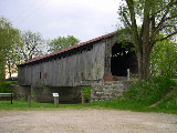 |
MULL
ROAD BRIDGE, 35-72-01, Town Lattice Truss, built in 1842, is located
SSW of Fremont, off Mull Road (TR 9).
The
GPS location is N41 15.650 W83 11.065.
|
WILLIAMS
COUNTY
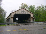 |
LOCKPORT
BRIDGE, 35-86-06, Modern Howe Truss w/laminated timber, no steel
beams used, built in 1999, originally a Howe Truss removed in
1919, is located at the intersection of CR 12 & CR 21.
The
GPS location is N41 32.796 W84 23.442.
|
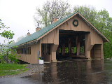 |
MONTPELIER
FAIRGROUNDS BRIDGE, 35-86-26, Pratt Truss, built in 2003, is located
in Montpelier, off East Main Street, over the St. Joseph River.
The
GPS location is N41 35.461 W84 35.946.
|
WYANDOT
COUNTY
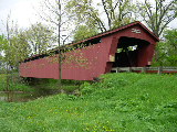 |
PARKER
BRIDGE, 35-88-03#2, Howe Truss, built in 1873, is located NNE
of Upper Sandusky, on Crane Road (TR 40).
The
GPS location is N40 54.180 W83 14.670.
|
 |
SWARTZ
BRIDGE, 35-88-05, Howe Truss, built in 1880, is located NE of
Little Sandusky, on CR 130.
The
GPS location is N40 46.247 W83 10.142.
|
|